
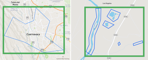
The Analytic system restricts the size of an AOI based on the bounding box of the polygon(s) defining the AOI boundary. The following examples show both the AOI boundary and the bounding box. The bounding box is shown in green.
The system restricts AOIs to confirm to the following criteria:
- Bounding box total area < 150 square kilometers
- Bounding box minium area > 0 kilometers
- Bounding box length and width < 50 kilometers
Area of Interest may be a single polygon or a multi-polygon.
Polygons with holes are not supported.
Feature Collections with 1 feature are supported.
Tools
The free on-line web app geojson.io is useful for converting KML and Shapefiles to the geojson format. This tool also offers a way to edit geojson if necessary.
Trouble Shooting and Known Issues
There is a known issue using geojson files created from KML files with HTML embedded in the description. If you have converted a KML file to geojson, you can use the geojson.io tool to change the description text and remove the HTML markup.
If a geojson you are uploading is too big, you may need to break the area into multiple smaller geometries using geojson.io or by drawing new boundaries using the provided drawing tools.